
Columbia’s Urban Heat Islands
Author: Brian Neiger, Superintendent of Forestry and Beautification, City of Columbia Division of Public Works
February 21, 2025
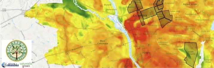
In 2022, the University of South Carolina, in collaboration with Benedict College, the City of Columbia, and engaged local community members, released an in-depth heat map study of Columbia. This comprehensive analysis revealed a critical issue: certain neighborhoods within the city experienced temperature differences of up to 18.5 degrees Fahrenheit compared with other areas of the City.
The report identified key factors contributing to this temperature disparity. Notably, areas characterized by extensive impervious surfaces—such as parking lots and pavement—were identified as significant heat sinks. One highlighted example is the Barnwell Street Lot (Stationary Sensor Site #7), where heat accumulation was particularly pronounced.
In addition, the study found that suburban residential developments lacking sufficient tree canopy cover were found to create "heat islands" that exacerbate energy consumption during peak summer months. In stark contrast, preserved forests and green spaces act as natural heat buffers, effectively moderating temperatures between residential zones and more developed land uses like highways and commercial centers.
The heat study underscores the urgent need for community-driven action to mitigate urban heat effects. Simple yet impactful initiatives—such as planting trees—can lead to temperature reductions of up to 18.5 degrees during sweltering summer days, ultimately resulting in significant energy savings. While it is true that the benefits of tree planting take time to realize, the positive impact on the environment and community health cannot be overstated. As the saying goes, “The best time to plant a tree was 30 years ago; the second-best time is now.” We can create a cooler, greener, and more sustainable Columbia for future generations by taking action today.